

Take the scenic route. Drive the dusty backcountry Cathedral Valley Loop through Capitol Reef National Park for the most impressive views in the park.
Capitol Reef is one of the Mighty 5 National Parks located in Southern Utah, known for their iconic red rock, arches and hoodoos. Capitol Reef National Park is the least visited of these five popular parks, but that doesn’t mean the scenery is any less incredible.
Most people stick to the trails centered around the paved Utah State Route 24 that runs through Fruita and by the Capitol Reef visitor center. You can pick fruit from the orchards planted by settlers in the late 1800s, hike the Cassidy Arch Trail or to the Hickman Bridge, and find thousand year old petroglyphs. But if you’re looking for an epic backcountry adventure, take the 57.6-mile dirt loop through Cathedral Valley for stunning desert panoramas and massive monoliths that erupt from the valley floor. This is one of the most beautiful scenic drives in Utah.
Scenic drives are a great way to explore a lot of ground in a shorter amount of time and see some pretty amazing sites. Some of our favorite scenic drives have been the PCH in California, the Hana Highway in Maui, and the Blue Ridge Parkway in the fall. This scenic drive through Capitol Reef National Park was up there with the best of them!
First I’ll be covering frequently asked questions about this drive. Then I’ll be sharing scenic stops to make along the way.

FAQ about driving the Cathedral Valley Scenic Byway
How long does it take to drive the Cathedral Valley loop?
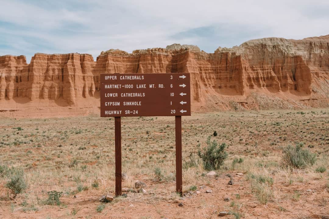
The complete loop is 70 miles, starting and ending at the at the Harnett Road River Fjord. It’s 57.6 miles of dirt track from the river back to the Highway 24 junction.
Most things I read said to budget about 4 hours, which estimates you’ll be driving about 15mph on the dirt road part. We went about 30 mph hour, but took the better part of the day by making stops along the way.
Do you need 4WD or a high clearance vehicle?
Yes. Just to be safe, I’d opt for a high clearance vehicle with 4WD or AWD. We did this in a Subaru Forester and had no problems at all. We spoke with a park ranger that noted the road was recently graded and they hadn’t had much rain recently, so it was in pretty good condition. There were still a few wet/muddy spots though from what looked like little creeks. You probably could’ve gotten away with an SUV without 4WD, but there were some ruts, soft sand, and washes that could be tough with a lower clearance vehicle. If the road has not been graded recently and there have been a lot of storms, you’re going to want a vehicle that can handle a rough road, mud, and some deep ruts.

Where does the drive start?
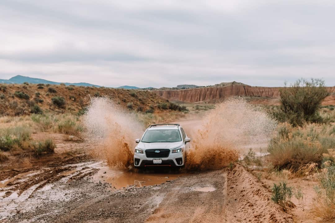
While this is a loop and you can go either direction, I’d recommend going clockwise and starting at the Harnett Road River Fjord (mile marker 91) to make sure your vehicle can cross the Fremont River. There is no bridge over the river. This is a little over 11 miles east of the visitor center on State Route 24.
The water level of the Fremont River varies depending on the time of year, and you don’t want to drive the other way and get to the end of the loop and find out your car can’t make the crossing. The river is pretty shallow in this spot (usually about a foot or less) and has a hard, rocky bottom. However, every year there are cars that end up getting water inside and have to get towed out.
How can I find out current road and weather conditions?
For more information about the current road conditions along the Cathedral Valley loop, check in at the Visitor Center, or call 435-425-3791. Press #1 for information, and then #4 for current road conditions. For weather conditions press #3. You can also check the weather on the National Weather Service online.
How busy is this road?
Often times, you’ll be the only one driving along this lonely dirt road. It is estimated that less than 1% of visitors to Capitol Reef visit Cathedral Valley, even though we think it’s the most impressive part of this park.
We passed a few other cars along the way, but for the most part we were alone. We didn’t have cell service very often, so make sure you have enough gas, food and water.


Are there bathrooms or water along this route?
There is no potable water available along this route. There is a pit toilet at the Cathedral Valley primitive Campground, located at about the half way point.
Can you camp along this route?
While driving along this road, you’ll exit and reenter the boundaries of Capitol Reef National Park several times. You can camp at the Cathedral Valley primitive campground located about halfway along the route. Or there are several places with free dispersed camping on BLM land along this road.
Scenic stops along the Cathedral Valley Scenic Byway
Bentonite Hills
If you start at the Harnet Road River Fjord, you’ll reach the Bentonite hills about 8 miles in. The soft rounded hills made of colorful layers of pebbled Bentonite Clay felt more like something you’d see on an alien planet rather than Earth.
Getting up close, the clay almost looked like jagged popcorn. It was formed millions of years ago during the Jurassic Period from volcanic ash. The clay is powdery to drive on when dry, but becomes incredibly slippery when wet, so don’t attempt to do this drive if it’s been raining.


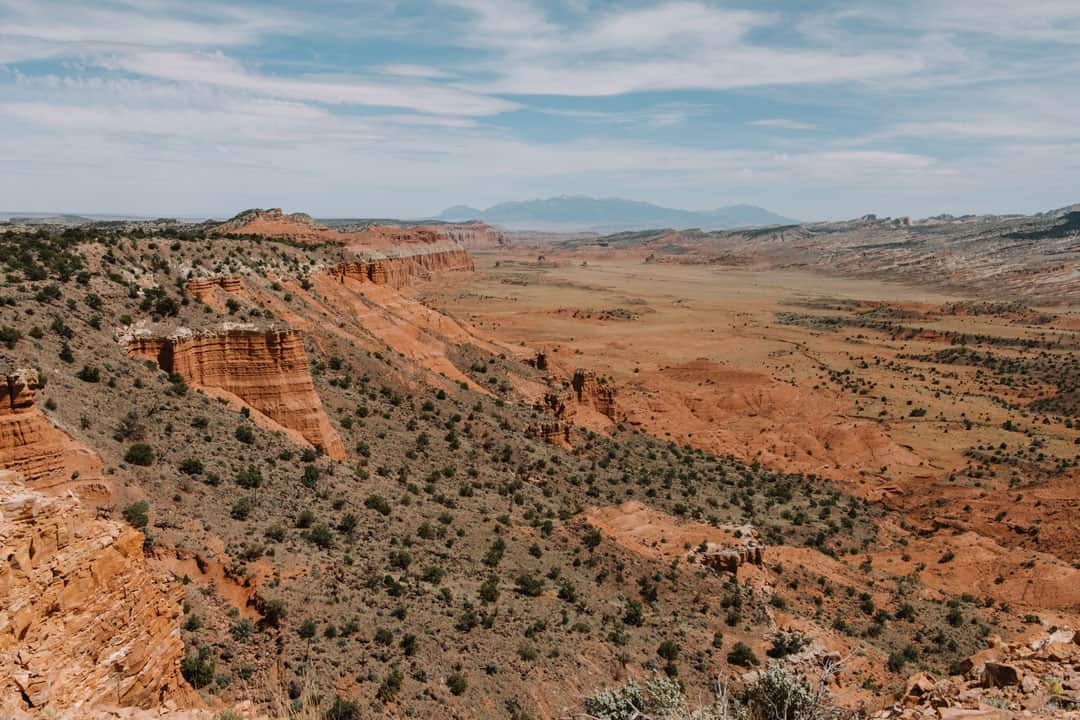
Lower South Desert Overlook
It’s a quick quarter mile walk out to the Lower South Desert Overlook where you can look out over the expansive valley and spot Jailhouse Rock, Temple Rock, and Thousand Lake Mountain.

Upper South Desert Overlook
Twelve miles down the road and you’ll be at the Upper South Desert Overlook, viewing the same valley but from the opposite side. The trail is about 0.2 miles to the edge of the cliff for unobstructed views.

Cathedral Valley Campground
The campground marks the halfway point of the drive. This is a primitive, no-fee campground with six sites and a pit toilet. There is no water. Each campsite has its own picnic table and fire grate. The Cathedral Valley campground is first-come, first-served and open year-round, though it may be inaccessible due to weather.
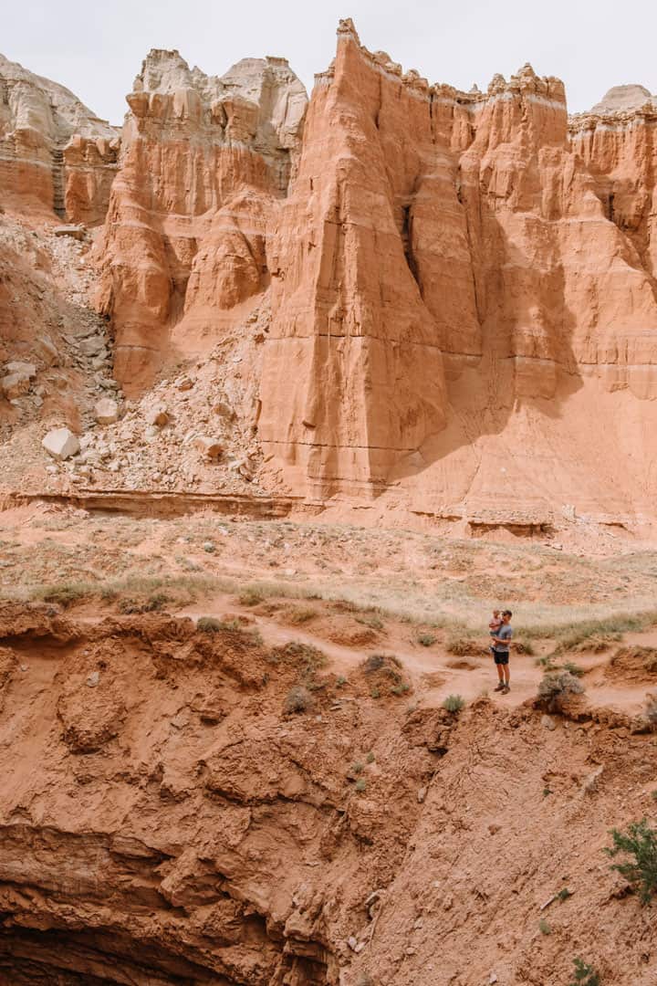
Upper Cathedral Valley Overlook
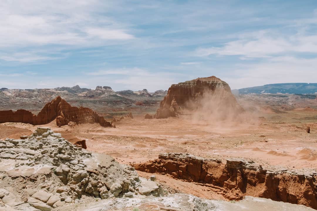
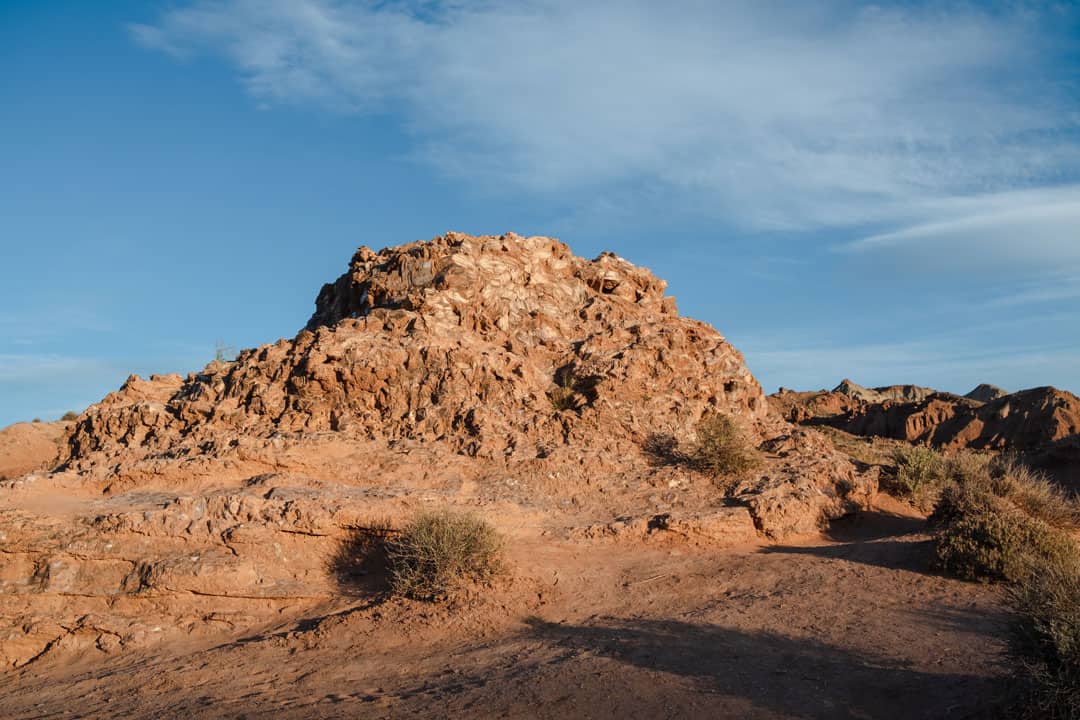
Take the short trail down to the overlook to view Cathedral Valley from above. The valley is walled in by fluted Estrada sandstone cliffs, and the occasional monolith juts up out of the desert floor. This area is also dotted dark green with bushy piñon-juniper trees.


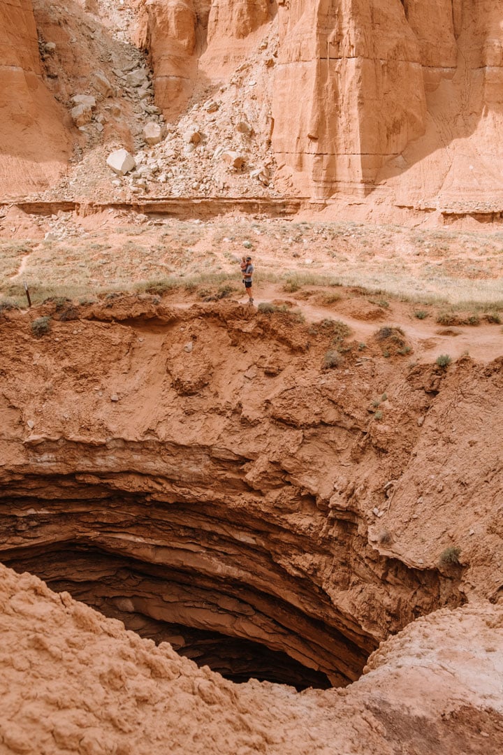
Gypsum Sinkhole
This sinkhole is massive. It formed when water dissolved the gypsum creating a hole that is 200 feet deep in some spots and almost 50 feet wide. The size and angles make it hard to get the whole thing in a photo unless you have a wide-angle lens or drone, but it’s worth the stop. Be careful around the edge, especially if you’re traveling with kids.


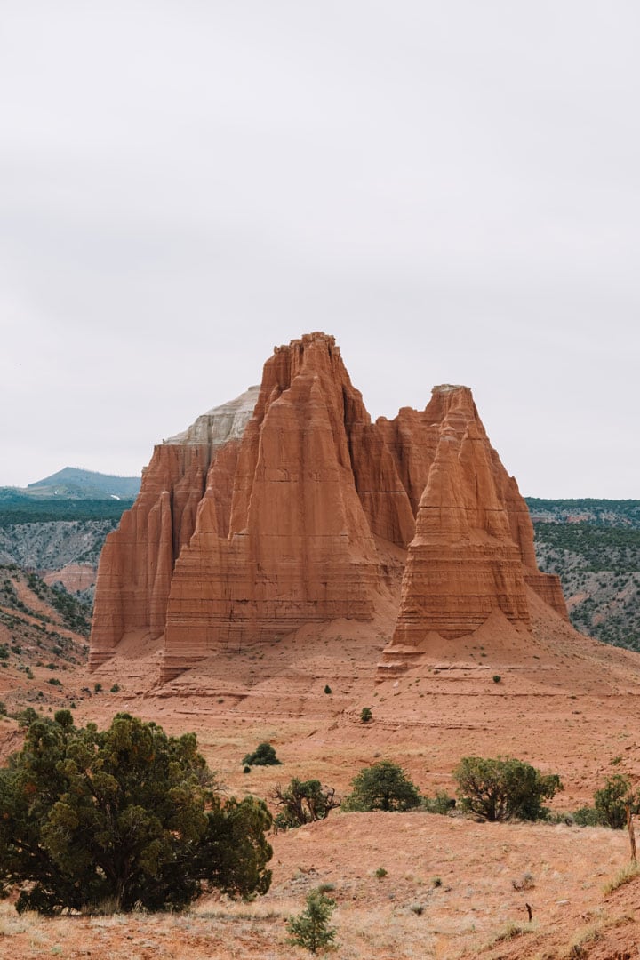
Temples of the Sun and Moon
This is really what we came to see: the massive monoliths made of pinkish-red Entrada sandstone that Cathedral Valley was named for. The road goes right by the Temple of the Sun and the Temple of the moon, so you can get up close and really feel how high they tower above I felt like a tiny speck standing in front of the monoliths, some of which reach heights of 500 feet.
We camped just a few minutes away from here on BLM land, right before the fence marking the entrance back into Capitol Reef NP. We stopped by in the evening to see these monoliths against a colorful sunset, and then watch the sky fade to dark blue.


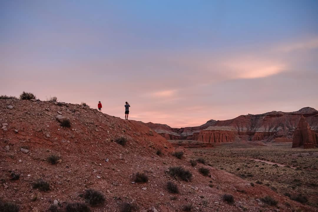

We came back in the morning to see the Temples of the Sun and Moon at sunrise. Most people think they’re best to photograph at sunrise, when they glow from the morning light. I think they look pretty incredible no matter the lighting, but it was cool to see them change colors.
If you don’t want to drive the whole Cathedral Valley loop and just want to visit this part of Lower Cathedral Valley, start the drive from Caineville on Highway 24 going counterclockwise. It’s about 15 miles and you should be able to do this portion of the dirt road with a 2WD car if conditions are good. You’ll just have to turn around and go back the way you came.


Glass Mountain
Glass Mountain is a small mound of large, flat selenite gypsum crystals, also known as moonstone. It’s located near the Temple of the Sun. The crystals formed when groundwater carrying dissolved gypsum flowed through the Entrada Sandstone, and then crystallized.
From here you can complete the loop by driving about 17 more miles along the dirt road until you reach Highway 24. The rest of the way back into Capitol Reef National Park is paved.


Capitol Reef – Cathedral Valley Scenic Byway Map
This is the route for the Cathedral Valley loop. Usually I’d embed the map directly, but when I do that it changes the route from the dirt backcountry road to paved highways. However, the link still works, so if you click on it, it should match the image below.


Like this post? Pin for later!


dave
Sunday 3rd of December 2023
I know it has been a while since this article was written, but whats considered high clearance SUV, would a lexus GX with At tires be adequate, it is 4wd with a locking center differential
nomanbefore
Thursday 29th of February 2024
Hey Dave, you can see the Subaru we took--looks like your Lexus might even be higher clearance. Mostly it depends on the conditions at the time you're going, which can vary a lot depending on time or year, rainfall, if the road has recently been graded etc. I'd call into the ranger station to see if they can give you an up to date report.
Jim
Tuesday 3rd of May 2022
Loved your blog. Will be in Capitol Reef next week & definitely plan on the Cathedral Valley Loop, pending road conditions. Thanks so much. If you have other Cap Reef “Must Sees”, I’d love a link to them. We really prefer off the beaten path!
Jim & Molly
H P
Tuesday 11th of January 2022
If you drive the whole FANTASTIC loop, you will see many "temples" just like those of the sun and moon farther west in the valley, between the Upper South Desert overlook and ~~ the Gypsum sinkhole area. So clockwise or counter, it won't matter.
I agree that this area is a hidden gem. We have driven it twice and can't wait to visit again.
Utah Photography Expedition: Day Six / Capitol Creek - Firefall Photography
Wednesday 6th of October 2021
[…] Valley is situated along an isolated 57-mile rough gravel/dirt/rock road known as Cathedral Valley Road. It has no gas, water, food, or cell service. Plus, at one point you actually have to drive across […]
Doreen Thomson
Sunday 25th of April 2021
Hi Kelly. Thank you so much for this extensive mile by mile post of your trip to Cathedral Valley. With Covid I'm having a terrible case of cabin fever. I usually post my travels so for 2020 I decided to do a virtual trip to the Trail of the Ancients and Grand Circle. This might seem a bit strange, but it has really kept me sane. We just arrived in Capital Reef (virtually) and decided to do the Cathedral Valley. We've been to Capital Reef lots of times but never the Cathedral Valley Loop. I was having a hard time trying to get a "feel" for it. You helped fill that gap. Thank you for the Google Map link. I just couldn't get it to work. If I have plagiarized from your posts, I apologize. I try to put things in my own words but sometimes other people just say things perfectly. I see your picture of the splash through the Fremont Ford and I was wondering if I could use it in my site. I have attached the page for our virtual trip. Doreen